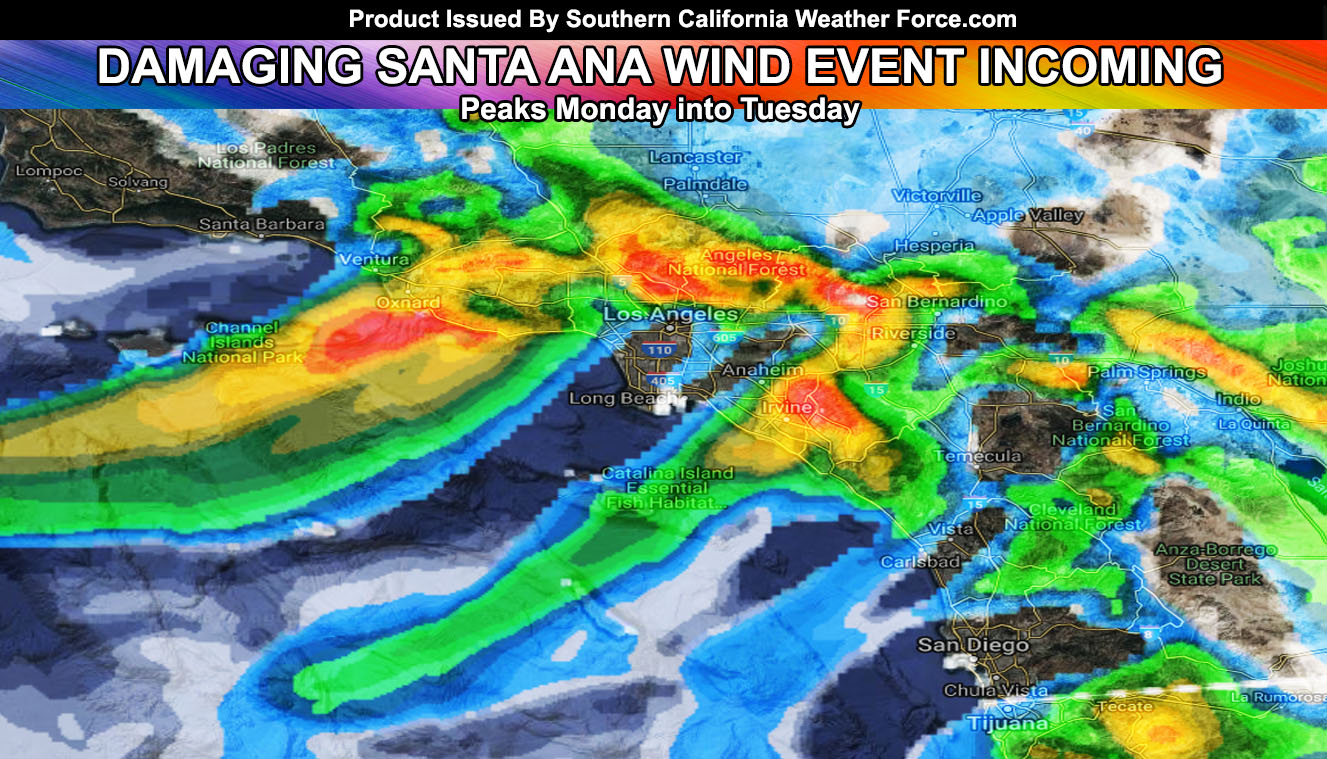
This will be the last update to the Santa Ana Wind Event scheduled to arrive by Monday morning and peak that day, lasting into Tuesday in spots. Some areas may see winds exceeding 80 mph, maybe even 100 mph at times. Read more for details.
Well here we are, the first Santa Ana Wind event of the season. A system diving into Arizona Monday into Tuesday will cause the winds to shift from onshore to offshore, with gusty northeasterly winds developing early (before sunrise) on Monday morning. Gusts in the main Santa Ana Wind prone zones will be 30-50 mph, however such areas near Moorpark, Fontana near the Mall, and parts of the Santa Clarita Valley may see wind gusts exceed 80 mph. As an average however the event will harbor 40 mph winds in the prone areas.
The area spots that usually do not get the Santa Ana Winds without upper support. However.. this event has such upper support and it will bring the winds into the San Gabriel Valley in areas like Sierra Madre, El Monte, Glendora, and Azuza. These winds near the foothills will exceed 45 mph and wind gusts as much as 30-40 mph in El Monte for this event, mainly Monday.
Gusts are furthermore expected in the nominal Orange County areas. Really cannot say every single location so if you are a full member, my wind map with cities and an address search is available on the member section – link – Click Here
These winds will be a cooler type wind. While Arizona is having there shower/thunderstorm activity, the backside of that system causing the Santa Ana Wind pattern will be rather cold. Temperatures in wind sheltered areas will be in the 40s at night and even 20s up in Big Bear, making this your first hard freeze of the season. Upper support is available for wind in the mountains too so wind chill factors will also be colder than the low temps.
Fire danger is low-moderate in the San Bernardino, Riverside, San Diego areas, including Orange County at the moment due to the recent rainfall received in many locations, but single digit humidity levels along with those gusty winds would put this warning included with my Fire Weather Watch. Areas near the lesser hit rainfall zones of the Santa Clarita Valley, Ventura County, and Kern County Mountains will have the Fire Weather Warning embedded in this for higher risks there.
With this warning is also the fact that Ontario Airport as well as some airports near Burbank may have delays, cancellations, and/or diverts to other airports. Check with your airline frequently between Monday morning and Tuesday.
Also… with the recent rains we will see trees and power-poles falling. This is because the soil is soft and the roots of trees are weakened. Many will fall with this event in the strongest hit areas.
The strongest winds will not arrive in the Riverside/San Diego County Mountain/Foothill zones until later Monday and into Tuesday with the secondary batch of gusts.
This same cutoff low that will impact our wind event will meander for a week or more. This will make the future forecast tough on where it ends up and who gets the precipitation from it. Right now the best I can say is the closer you are to the Eastern Deserts the better chances you get for more precipitation in a week time-frame starting this next week.
Most dangerous spot detected: Chaffey College in Rancho Cucamonga on Monday
End
NOTE: Premium members. If you are signed up, your login is your e-mail address and the username and password as the password. You can change the password
Ongoing Ad – The Southern California Weather Force has a member section with LIVE UPDATES FOR EVENTS and rain, wind, thunder, tornado etc models that are personally updated by me with each Santa Ana Wind or storm event. You also can get e-mailed alerts via a slew of micro-climates. Check the member section for details on how you can support this service.. along with getting service in return… Click Here To Join or Upgrade Via The Member Section
Please remember if upgrading to CANCEL YOUR PAYPAL PAYMENTS. Login and cancel the reoccurring payments.
The Southern California Weather Force has different Facebook groups that you can ask for notifications from in order to get the latest posts affecting those regions. If that area is talked about in an article, alert, and such .. it’ll be posted there and you can be notified.
Comments are usually DISABLED as we do like to keep this as an information giving group and replies from others in the notification may annoy some.
Find your micro-climate group here – https://www.southerncaliforniaweatherforce.com/scwf-weather-alert-facebook-groups-by-region/
EMAIL ALERTS? Many micro-climate zones to choose from to get custom alerts from thunderstorm, wind, flood, surf, heat, cold, storm, and much more with the premium e-mail alert system, the most advanced zone alert system in Southern California – Click Here To Join!
SOUTHERN CALIFORNIA ONLY: if it does not say “Liked” LIKE The Page Below and join thousands of informed weather forecast viewers in our region for more of the updates! noticeable
BEHIND THE SCENES FORECASTS/UPDATE PAGE: if it does not say “Liked” LIKE The Page Below and join thousands of informed weather forecast viewers in our region for more of the updates! noticeable

