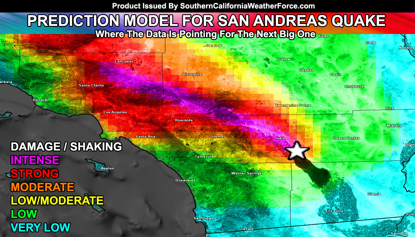
 Models elsewhere have enabled me to input a few uplift values into my own model and finalize the predictive area of the next San Andreas Fault rupture. Read on for where … The reason I did this was because I am fluent in patterns and if someone shows me a model for a certain element … I will be able to find out ‘why’ certain things happen based on these models … and the GPS data all suggests that the next rupture point will be … and was used in the San Jacinto Fault Earthquake earlier this month as a match. We have zero to two years for this to go.
The image depicted in this article is where the San Andreas will likely rupture next … which is near the city of Mecca, California … in the extreme Southern Coachella Valley region. The rupture length would be up through the Banning Pass … San Bernardino Mountains … Cajon Pass .. .Los Angeles Mountains .. .and end near Palmdale, California. The length of this would produce a possible magnitude 7.7 to 8.1 Earthquake.
That section of the San Andreas is creeping northwest along the fault at the surface while the bottom of it deep down .. is stuck … this is stretching the zone out and pretty soon the ‘stuck part’ will snap forward to meet the creeping part and that will be what creates the quake.
This will be updated on at our Facebook Page so if you haven’t .. go like it. It isn’t just earthquakes .. It is a full-time weather forecast office alert system …
Click here to go to our page – https://www.facebook.com/scweatherforce
The image depicts that seismic waves would travel northwest from the rupture point and through the Banning Pass .. acting similar to the wind patterns … While these are underground .. the pattern of flow is the same as wind coming through that area. Basically if you smelled the Salton Sea Stench before … you will feel more shaking from it. It is the exact same pattern movement with the stench blocked from San Diego, where shaking should be way less.
These waves would jet through the Inland Empire’s northern end right through the Ontario Airport … and keep moving west along the I-10 and 210 freeways into the Los Angeles Basin. Southern end of the waves would hit Northern OC .. and residual wave motion will hit the Eastern Ventura County basin areas. Shaking would be intense in all High Desert areas in the Victor Valley zones east to Palmdale and Lancaster.
Less shaking would be felt in San Diego County .. where wave motion through the Banning Pass and deflection of the waves from the San Diego and Riverside Mountains would be. This would also bring lighter shaking for areas northeast, east, and south of the rupture zone. So the Imperial Valley areas would not feel the shaking as intense as you did with the Easter Earthquake in 2010.
So this was made possible with some GPS/GIS data … with Topographical data for elevation from the USGS. It will not be entered into any scientific journal …
The reason I did this was because I am fluent in patterns and if someone shows me a model for a certain element … I will be able to find out ‘why’ certain things happen based on these models … and the GPS data all suggests that the next rupture point will be near Mecca, California … and pretty soon as well.
