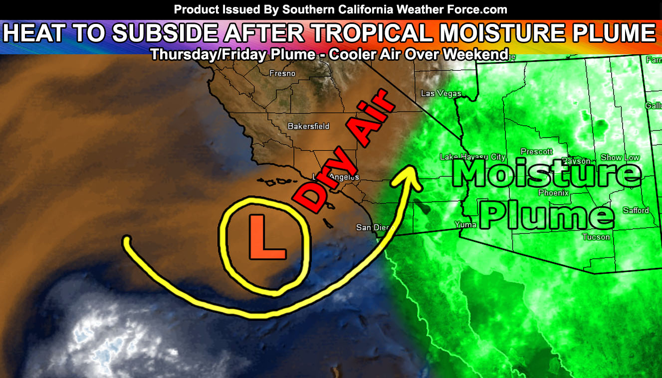
The heat happening now through Thursday is expected to break drastically by Friday into the weekend as a cold-front sweeps the area. Tropical moisture is now visible on satellite starting to come in on Thursday through Friday so read on for details …
Temperatures peaked around 2pm this afternoon with 95-100F in the inland areas, 80s in the basin, and 100s in the low deserts, with some 95-101 in the higher desert areas. This heat is expected to drop some tomorrow with the introduction of tropical clouds. As stated in the previous article, we will see the start of tropical moisture on Thursday and a nice sunset for a photo op.
Ongoing Text Ad: Furthermore we parted with our main summer-time advertiser and will need help from viewers/readers this Summer. So if you are interested in helping you can donate to SCWF in just a couple clicks by CLICKING HERE. I do appreciate all the help to make it through this Summer Monsoon Season. We are now over 1/2 to the goal to keep operations this Summer without an advertiser. Thank you everyone who has helped thus far. If the monsoon kicks up in July you’ll want to have this service operational.
Already you can see the moisture band moving across Baja, Mexico. This band should be in the San Diego to Imperial County zones by early Thursday morning.
An upper level low just to our southwest will also be in place to trigger lifting from 15,000 feet and above so any moisture entering our area will lift up, mainly San Diego County up to the Eastern Inland Empire and east into the low desert areas, including the Riverside and San Diego County Mountains between Thursday morning and Friday. The current SCWF Fire Weather Watch I issued yesterday (click here to read it) looks good and so does the Special Weather Statement (click here to read it).
Activity should first develop in the elevated areas of the Southern border of the San Diego/Imperial County areas near the Octotillo forecast areas along I-8 on Thursday morning and spread northward from there.
SOUTHERN CALIFORNIA ONLY: if it does not say “Liked” LIKE The Page Below and join thousands of informed weather forecast viewers in our region for more of the updates! noticeable
At the current time I do see the western extent of the tropical moisture plume it may miss most of the Inland Empire with the border being the Coachella Valley, Riverside / San Diego Mountains with activity happening to the east. This will be caused by a persistent trough for drier southwest flow in the needed moisture levels for any activity.
I also do not see this being a flood event or a severe thunderstorm event. Consider it the first taste of tropical moisture before we get hit in July.
The heat advisories will expire on Thursday night.
On Saturday a front will zip through the area, increasing the onshore flow. This will bring drizzle/light rain along the coastal zones and maybe somewhat inland, but not much. Enjoy the weekend.
The week after that is split on either back in the 90s or maintaining the 80s for the inland valley areas. Will wait through the weekend to get a better handle on it.
BEHIND THE SCENES FORECASTS/UPDATE PAGE: if it does not say “Liked” LIKE The Page Below and join thousands of informed weather forecast viewers in our region for more of the updates! noticeable
Things to note are as followed;
- A colder than normal Summer does not mean we won’t have times of a heatwave or two. It means overall it’ll be colder than normal.
- Tornado activity will remain this Summer in the desert and Central/Eastern Inland Empire areas. Thunderstorms elsewhere likely …
- Monsoon Season starts June 15th, however this year will be a mid-start, likely toward or in July.
- To remain active this Summer we are keeping the member section open to the public but as a ‘donation’ for help, by Clicking Here you’ll help this service remain into Summer.
Click Here To Find Me On TWITTER.

