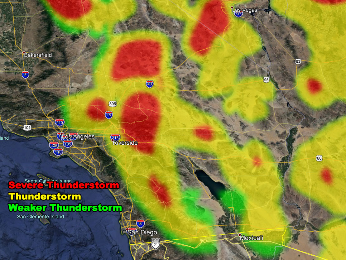
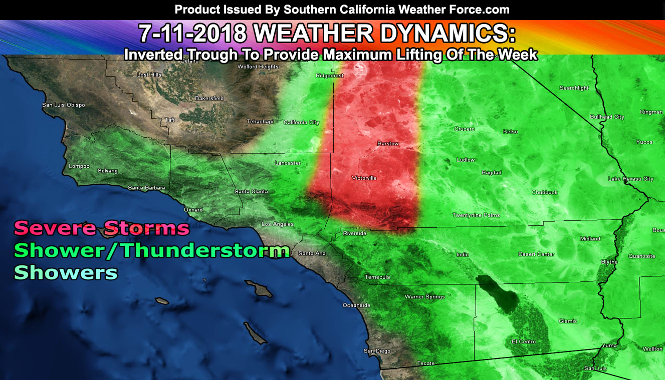
The micro-climate alerts went out for severe thunderstorms, thunderstorms, and showers, including Flooding in spots earlier this morning for many micro-climate locations served here at Southern California Weather Force. The inverted trough is going to provide the most lifting in the area. Find out if your area is in an alert by reading on …
The SCWF Severe Thunderstorm Watch is in effect for The San Bernardino Mountains … The Metro High Desert … Wrightwood zones. An inverted trough will move through the area today. Unlike yesterday where the culprit for failed development was strong winds at 18,000 FT shearing the storm tops off .. we will not see that today. Sufficient clearing over the area is enough to pop off thunderstorms early, likely well before noon.
As the day moves along these storms will intensify in the watch area. Movement will be to the southwest and generally the southwest moving storms give the entire metro high desert multiple rounds of storms. It also gives the mountains a lot of them due to the convergence zone in the area.
Because of the deep-layer moisture in place … there will be a flash flood potential with today. Hail/gusty winds are also possible …
The SCWF Thunderstorm Watch is in effect for The Inland Empire … Eastern half of the San Bernardino Deserts … Riverside County Mountains and Deserts … Imperial County … San Diego County Mountain/Desert zones, west to Fallbrook, Rainbow, and Escondido … An inverted trough will move through the area today. Unlike yesterday where the culprit for failed development was strong winds at 18,000 FT shearing the storm tops off .. we will not see that today. Sufficient clearing over the area is enough to pop off thunderstorms early, likely well before noon.
As the day moves along these storms will intensify in the watch area. Movement will be to the southwest and generally the southwest moving storms give most Inland Empire areas some type of activity, with more chances for thunderstorms the closer to the foothills you are than in areas like say Corona, the furthest southwest where activity would be on a weakening trend. Storms today could produce flash flooding with the strongest cells. Eyes to the skies.. If you approach a flash flood .. turn around.. don’t drown…
Further south into San Diego County.. the flow being out of the east will allow for mountain development to try to make it off the foothills and into areas like Rainbow/Fallbrook and even Escondido.
This is also for the Morongo Basin and Low Desert zones as well. Multiple convergence boundaries will form in these areas and shots of thunderstorms will likely hit … with a movement generally from the southeast behind the inverted trough. Interesting storm movements in different sectors of this watch today …
The Weather Advisory is in effect for the Santa Ana Mountains … Northern Orange County Basin … Los Angeles Basin … SGV/SFV/SCV … Antelope Valley … Edwards Air Force Base … An inverted trough will move through the area today. Unlike yesterday where the culprit for failed development was strong winds at 18,000 FT shearing the storm tops off .. we will not see that today. Sufficient clearing over the area is enough to pop off thunderstorms early, likely well before noon.
As the day moves along these storms will intensify in the watch area. Movement will be to the southwest and generally the southwest moving storms are favorable for the Antelope Valley and Los Angeles County Mountains.
Movement from there would be fast enough for a thunderstorm AND/OR shower to make it to the Los Angeles Valley/Basin areas, including the SGV/SFV/SCV areas. Flash flooding is possible in the mountain/desert areas with any stronger storm.
Now tonight is an interesting pattern. This inverted trough nudges northward some and puts the LA Mtns to SCV/SFV in upper divergence for lift. A crossing vort would aid in updraft development and we could continue showers in those regions.. with a movement due west toward Ventura/Santa Barbara County … I’ll leave the advisory up through some of tonight for that …
May need to get a short term forecast product out for Ventura/Santa Barbara County as showers could easily move over those areas later on.. given the lifting of the inverted trough toward the area.
Tomorrow the flow is more normal during our monsoon, early on toward the northwest but after 12pm to the north. This would return less chances of inland valley events and more for the mountain and desert regions.

Ongoing Text Ad: Furthermore we parted with our main summer-time advertiser and will need Summer help each year.. but you made it possible! If you are still interested (and I had many asking me how they can pitch in for this) in doing addon and upgrade help you can donate to SCWF in just a couple clicks by CLICKING HERE. Maybe we can get the video green-screen forecast software back!. I do appreciate all the help, especially making the goal to remain operational through the Summer. We are now complete on the goal keep operations this Summer without an advertiser. Thank you everyone who has helped. At this point it is about upgrades/addons as the server operations are now paid for.
EMAIL ALERTS? Many micro-climate zones to choose from to get custom alerts from thunderstorm, wind, flood, surf, heat, cold, storm, and much more with the premium e-mail alert system, the most advanced zone alert system in Southern California – Click Here To Join!
SOUTHERN CALIFORNIA ONLY: if it does not say “Liked” LIKE The Page Below and join thousands of informed weather forecast viewers in our region for more of the updates! noticeable
BEHIND THE SCENES FORECASTS/UPDATE PAGE: if it does not say “Liked” LIKE The Page Below and join thousands of informed weather forecast viewers in our region for more of the updates! noticeable

