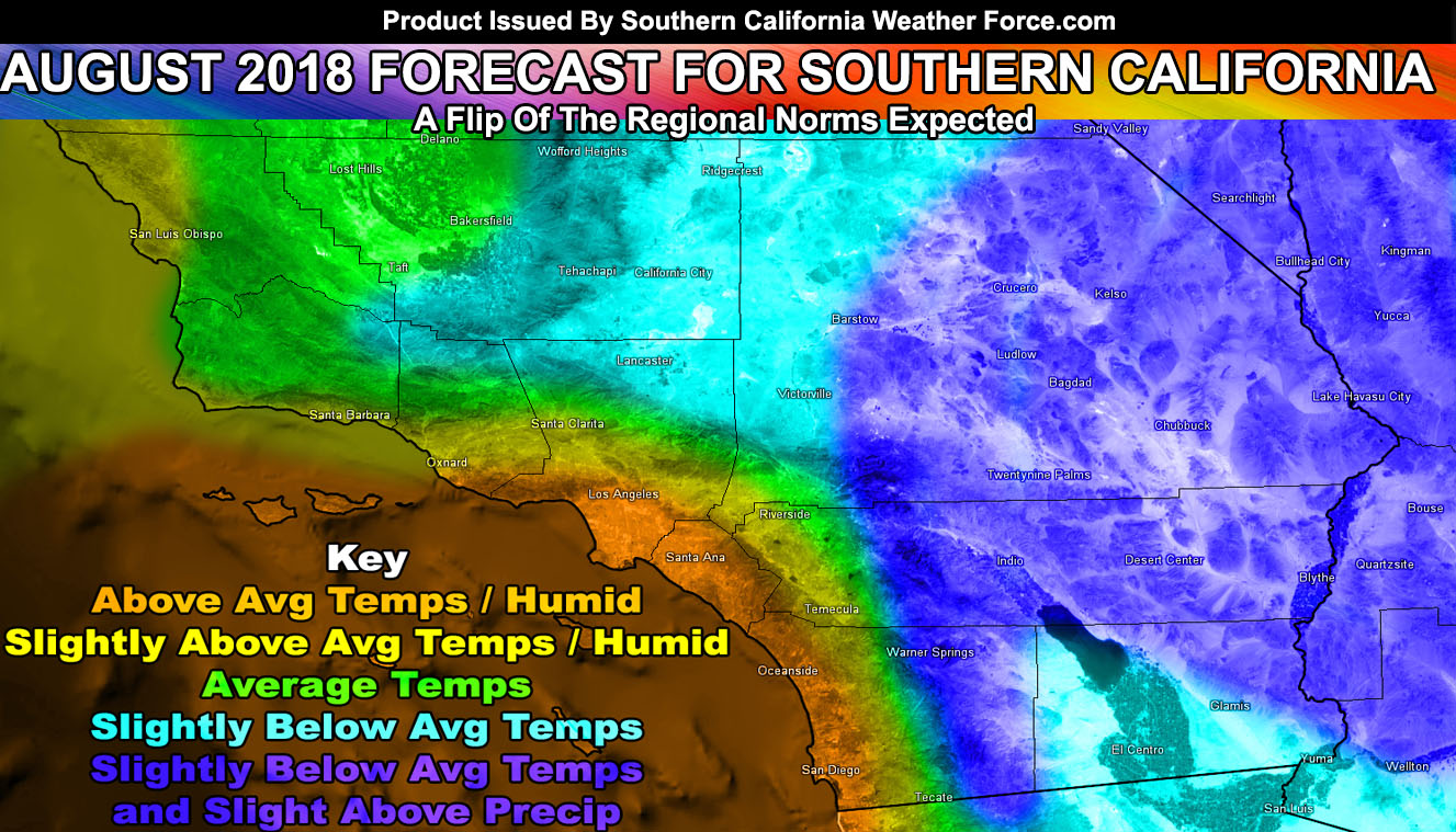
July 2018 went as expected with above normal temperature conditions and August 2018 will have a mixed bag and even some abnormal flip in regional temperature normals on what each region is use to. Read on for details on why.
Normally we have our hottest month in August. However, this time I’m thinking this will not be the case. Our hottest stretch out of the meteorological summer months of June, July, and August this year is July. I am sure many of you are noticing the humidity in the metro areas this season. The humidity this season is quite normal if you are near the coast. The water however is warmer than normal, nearly as warm as July 2006 at the time. This warmer water combined with an onshore flow is keeping the metros humid. The northwest flow around Vandenberg is keeping that area drier while the Catalina Eddy is sucking up air from the south (tropical low levels) and moving into San Diego, Orange, The Inland Empire, Los Angeles, and Ventura County. We have been more humid as a result of the warmer than normal water.
This warm water however does not extend west of Ventura and maintains in the bight of Catalina/San Clemente Island and the associated nearby land regions already mentioned. So now you have the explanation of the humid conditions what will August hold?
I am actually going with slightly above normal in the coast/valley/basin areas and below normal in the high and low deserts. Now, the deserts are always hot in the Summer due to the sun angle so do not get me wrong you will see 100s. However, what this means is that you will not see the multi-days of 110-115+ like usual and if you indeed live in the high or low desert you will notice the difference.
I am keeping the metro zones south and west of the mountains in slightly above normal due to the warmer waters offshore. Numerous monsoonal moisture shots will enter the region, which could go to the coast as well.
August 2018 will put a wrench in my average to cooler than average forecast for the region’s meteorological summer months. June was way below average and July was above. We are maintaining at average at the current time. We will end with slightly above temps in the metros and below average for the mountain and desert areas, which is unusual as this is a complete flip of the regional area’s norms.
This is tough to put into a forecast verification but as a ‘whole’ calculation of the landmass of Southern California we will end August at slightly below average, which would, if correct, make the total value of the region slightly cooler than normal of a Summer.
EMAIL ALERTS? Many micro-climate zones to choose from to get custom alerts from thunderstorm, wind, flood, surf, heat, cold, storm, and much more with the premium e-mail alert system, the most advanced zone alert system in Southern California – Click Here To Join!
SOUTHERN CALIFORNIA ONLY: if it does not say “Liked” LIKE The Page Below and join thousands of informed weather forecast viewers in our region for more of the updates! noticeable
BEHIND THE SCENES FORECASTS/UPDATE PAGE: if it does not say “Liked” LIKE The Page Below and join thousands of informed weather forecast viewers in our region for more of the updates! noticeable

