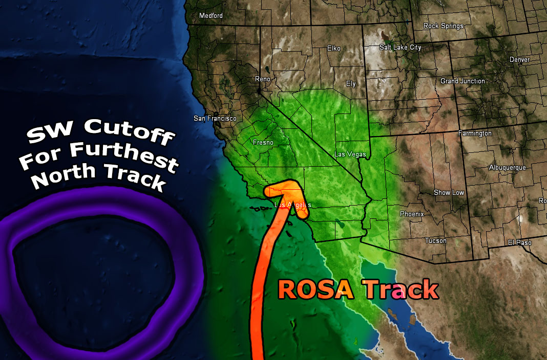
Yesterday ROSA became a Tropical Storm. The forecast here slated it to become a hurricane today and this was step three. Step four is monitoring the track and believe it or not we’ll need a cutoff low to drag her into the region. Read on more for details, including the forecast for the Miramar Air Show this weekend and three detailed scenarios on ROSA.
Rosa is a category one and I expect it to become a Major Hurricane (Category 3) by tomorrow (Thursday). This status must be obtained if she is going to make a turn northward toward the mainland of Baja, Mexico and the Southwestern United States. Without obtaining category 3 status and above she’ll continue moving west-northwest and miss the crucial north turn completely. I do not see this happening so this thing is going to head northward by the weekend.
Ongoing Ad Until End Month – The Southern California Weather Force has a member section with rain, wind, thunder, tornado etc models that are personally updated by me with each Santa Ana Wind or storm event. You also can get e-mailed alerts via a slew of micro-climates. Usually $50 a year the price has nearly been cut IN HALF as the discount that will go through till the end of September 2019. This is a yearly discount that I do so if you are a monthly contributor of $5 or $6.50 then I would upgrade to this and do it yearly each fall and you’ll save more.
Deal ends at the end of this month (September) so Click Here To Join or Upgrade Via The Member Section
Please remember if upgrading to CANCEL YOUR PAYPAL PAYMENTS. Login and cancel the reoccurring payments.
Various scenario exist for ROSA. The system will need to rely on the placement of the trough and/or cutoff low that will nudge into our region after the weekend. This cutoff feature is showing up in 75% of my numbers and if it moves southwest of us it will be enough to drag ROSA and the associated dynamics over the Southern California area.
Scenario 1 involves a miss completely, which the storm curves toward Tucson, Arizona and misses the entire forecast area, including the moisture associated with it. This will only happen if the trough moving into the area toward the end of this weekend does not cutoff. It would shove the system way east, ending our chances.
Scenario 2 indicates that a cutoff would form due west of Southern California and help nudge ROSA further westward into our forecast area through Baja, Mexico and into the Colorado River Valley. This is the scenario I’ve been looking at since day one. But… there’s another I am curious on.
This is scenario 3. Hurricane ROSA is strengthening faster than projected and if this is correct she will maintain a northwest track of quite a while before turning due north towards the mainland. This would favor a cutoff to the southwest of Southern California and pull her directly northward into the heart of Southern California.
Out of the scenarios below.. I favor a blend between scenario 2 and 3. I do think the expected strengthening of ROSA will alter the track more westward than eastward and that the cutoff will establish to our west in the Pacific.. allowing for ROSA to be closer to us on landfall. I do also believe that the upper level lift associated with such a cutoff will interact with the moisture, producing the chance of more widespread activity after the weekend. So the rain that fall across San Luis Obispo, Santa Barbara, and even Kern County won’t be directly from ROSA’s path but more of the upper level lifting cutoff to the west as the source.
Two completely different weather systems look to come together and affect our region. This should start the rainfall totals for the season.. which still looks good at the moment.
As for the Miramar Air Show, we are looking at a steady onshore flow through the event with low clouds/marine layer in the area along the coast and inland. At times the cloud deck will be too low to really enjoy much.. but at times later in the morning/afternoon it coule briefly clear to the coast. No gusty winds or high temperatures expected.
The Southern California Weather Force has different Facebook groups that you can ask for notifications from in order to get the latest posts affecting those regions. If that area is talked about in an article, alert, and such .. it’ll be posted there and you can be notified.
Comments are usually DISABLED as we do like to keep this as an information giving group and replies from others in the notification may annoy some.
Find your micro-climate group here – https://www.southerncaliforniaweatherforce.com/scwf-weather-alert-facebook-groups-by-region/
EMAIL ALERTS? Many micro-climate zones to choose from to get custom alerts from thunderstorm, wind, flood, surf, heat, cold, storm, and much more with the premium e-mail alert system, the most advanced zone alert system in Southern California – Click Here To Join!
SOUTHERN CALIFORNIA ONLY: if it does not say “Liked” LIKE The Page Below and join thousands of informed weather forecast viewers in our region for more of the updates! noticeable
BEHIND THE SCENES FORECASTS/UPDATE PAGE: if it does not say “Liked” LIKE The Page Below and join thousands of informed weather forecast viewers in our region for more of the updates! noticeable


