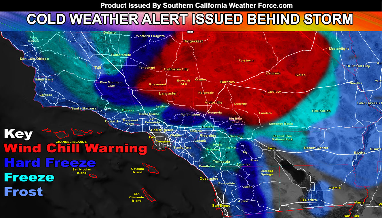
Pacific Storm Warren is a cold system and heavy snow fell on the San Bernardino and Los Angeles Mountains, with advisory level amounts in the Kern and Riverside Mountains. The system will move out after 10pm tonight and the dry air coming in has prompted me to issue a cold weather alert along with a wind chill warning in the High Desert so read on for details and what to expect coming up.
A cold front is swinging through the area this evening and will move out by tonight. The dry-air behind the front will bring a dramatic drop in temperatures across most of the forecast area, the exception being the LAX/Central LA Basin and Downtown San Diego Proper zones where temperatures should be near 40.. still cold.. not frost advisory criteria.
The following areas are in warnings/advisories here at SCWF; Mountain areas are not in warnings because you know it is always a hard freeze there with these.
Freeze Warning – Kern Valley … Inner SLO … Eastern half of the Inland Empire … Banning Pass … Morongo Basin … High Desert to Antelope Valley.
Frost Advisory – Western half of the Inland Empire … San Fernando and Santa Clarita Valley … San Gabriel Valley … Santa Barbara and San Luis Obispo County Coast/Valley … CO River Valley … Parts of the Imperial Valley … Orange County … San Diego Coast/Valley/Foothills, NOT including Downtown San Diego proper.
The High Desert and Top of the Cajon Pass is under my Wind Chill Warning – Click Here To View That
WHAT IS NEXT?: As for the rest of the week.. expecting dry weather up through until the weekend when a couple more impulses are looking to come in. They do not seem too strong of rainfall producers but I will touch-base on them as we near the weekend. For now the focus is mid-month where the jet stream angles in such a way to bring even stronger storm systems to the forecast area. This will be my next focus so stay tuned. After over a week of forecasting I will be taking a couple days break. Thanks for choosing Southern California Weather Force! –
For Main Facebook Page Click Here
End Article
NOTE: Premium members. If you are signed up, your login is your e-mail address and the username and password as the password. You can change the password
The Southern California Weather Force has different Facebook pages that you can join for a better in-depth analysis of storm and wind events …
Click here to find your area today!
EMAIL ALERTS? Many micro-climate zones to choose from to get custom alerts from thunderstorm, wind, flood, surf, heat, cold, storm, and much more with the premium e-mail alert system, the most advanced zone alert system in Southern California – Click Here To Join!
SOUTHERN CALIFORNIA ONLY: if it does not say “Liked” LIKE The Page Below and join thousands of informed weather forecast viewers in our region for more of the updates! noticeable
BEHIND THE SCENES FORECASTS/UPDATE PAGE: if it does not say “Liked” LIKE The Page Below and join thousands of informed weather forecast viewers in our region for more of the updates! noticeable

