
El Nino isn’t done yet as another Martin Storm Pattern develops with above average rainfall for the week after March 20th onward with the next storm after Carolina being Pacific Storm DICK, which will start off as a category three with room for an upgrade as the days go on so read on for details …
The Santa Ana Winds are still blowing out there today and will continue to blow ahead of Pacific Storm DICK, which will shove them away. As a strong surface low out east carved a large trough along the Western United States, gusty drainage winds were the result. These winds are expected to be stronger than what we are currently seeing, peaking Friday morning around the morning commute with wind gusts 30-50 mph below the pass and canyon regions. This is a nominal Santa Ana Wind Pattern with no upper support. If you normally get them then expect them … if you do not then do not expect them. The wind model I provided on the main page (Click Here And Go To Santa Ana Wind Tab) will allow you to see what intensity scale you are under this event.
The winds will die down later on Saturday into Sunday. As previously expected, a warm Sunday is expected with no rainfall and a perfect NASCAR final event for the Autoclub 400. I will see you there somewhere near Turn 4. Also, come support the Norco Team’s booth as they will be selling Hotdogs and Soda!
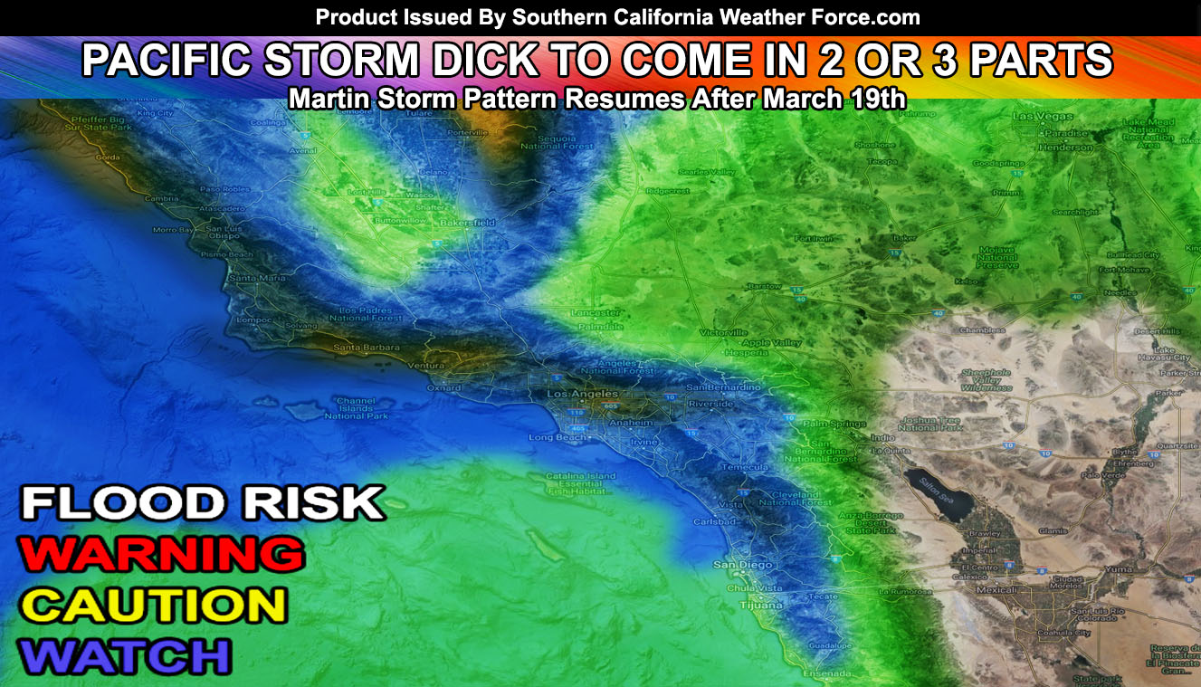
Now … I am still thinking the first system around the 20th will be a weaker type. My numbers continue to show this. The second one is the one that would be Pacific Storm DICK. DICK may come in two or three parts with a large parent upper system in the Northeast Pacific Ocean similar to Major Pacific Storm Trump’s impulses. As of this far out my precip model has watch and caution for flood risks so this is interesting for this time of year, to say the least. Systems that come into the forecast area in later March generally pick up better instability and therefore the thunderstorm risk does go up. We will have another break in the activity toward the end month. Preliminary numbers are showing the effects of our El Nino will go through April and May.
These systems will translate into tornado alley in the TX/OK/KS zones as they move east so your tornado season has only just begun over there.
As always, stay tuned to Southern California Weather Force for further details. Look at the links below for help, including the ‘Optional’ link if you want to see the addtional maps on the main SCWF page. Everything is updated accordingly before an event.
OPTIONAL: Southern California Weather Force main page now has models, agendas, the alert map, and other things updated during storm events. You can bookmark the main site and check back during an event for the latest updates.
Click here to view the main page
EMAIL ALERTS: It pays for itself in one storm system. A very affordable e-mail alert system that only gives you SCWF weather alerts in YOUR micro-climate area.
Click here to join
MICRO-CLIMATE ALERT FACEBOOK GROUPS: Find yours today!
Click here to join
SOUTHERN CALIFORNIA ONLY: if it does not say “Liked” LIKE The Page Below and join thousands of informed weather forecast viewers in our region for more of the updates! noticeable
BEHIND THE SCENES FORECASTS/UPDATE PAGE: if it does not say “Liked” LIKE The Page Below and join thousands of informed weather forecast viewers in our region for more of the updates! noticeable