Issued Zones: All metro areas south/west of the mountains except the Inland Empire …
Site: Southern California Weather Force has issued a Squall-Line Watch, Santa Ana Wind Advisory, and embedded Flood Warning effective Christmas Night through Thursday at 3pm and then a Santa Ana Wind Advisory from Thursday 3pm till Friday at 9am …
Date: 12/24/19 at 1:50pm PT
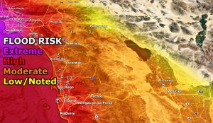
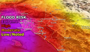
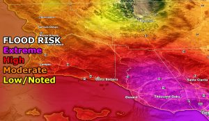
Forecast: A strong storm system will move into the region Christmas Night through Thursday. This storm system has a strong low-level jet with it along with the flood risk model showing high to extreme rainfall rates in a short period of time.
This means that in addition to this alert, a FLOOD WARNING is also in effect over-lapping it. Easily can see the 1-2″ rainfall amounts in some locations, but the focus will be the rainfall rates and SCWF Flood Risk Model. With this will come gusty winds in excess of 30-40 mph at times Christmas Night into Thursday afternoon.
Believe it or not, offshore Santa Ana Winds will be right behind it Thursday evening and night, diminishing Friday morning. High rainfall rates in the flood zone with the winds WILL TOPPLE TREES AND POWER-LINES IN SPOTS SO BE CAREFUL.
Because this has some low-level shear out of the southeast and meager instability, there is a chance of embedded tornadoes at times anywhere in the alert zone Christmas Night through Thursday morning …
How to get these alerts with a premium subscription? (100 percent delivery time)
Click Here For Options
Join A Micro-Climate Group On Facebook For These Alerts? (50 percent delivery time)
Click Here To Find Your Location Served By SCWF Today!
10 mile rule: These alerts issued on this site means that within your zone and 10 miles from you will see the event forecast for. You may or may not see the event but it means you are in the zone or 10 miles from where someone will.
Forecaster: KM


