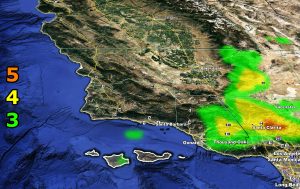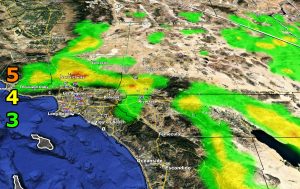
Issued Zones: Inner Ventura Basin … SCV/SFV … Los Angeles Mountains … Cajon/Banning Pass … San Bernardino Mountain Rim … Riverside/San Diego Mountains … Western half of the Inland Empire from the I-15 corridor … Needles …
Site: Southern California Weather Force has issued a Santa Ana Wind Advisory effective Tuesday …
Date: 4/13/20 at 11:35am PT
Forecast: Offshore winds are expected to develop overnight tonight and last through Tuesday. Wind gusts with it will range from 30 to 50 mph with the strongest expected below the passes and canyons. Temperatures are expected to be in the 70s with this.
A return of cooler temperatures and some precipitation with a weak system is expected by end week. Use the SCWF wind intensity model images below for your area, the Cajon Pass being the 5th one.
5. Slight damage occurs to buildings, shingles are blown off of roofs. HIGH WIND WARNING CRITERIA – High Profile Vehicle Roll-Over Possible if weight is not corrected.
4. Twigs and small branches are broken from trees, walking is difficult. BLOWING DUST CRITERIA if in an area known for blowing dust.
3. Large trees sway, becoming difficult to walk. POWER SHUTDOWN THRESHOLD during any high fire risk. WIND ADVISORY CRITERIA
Join A Micro-Climate Group On Facebook For These Alerts?
Click Here To Find Your Location Served By SCWF Today!
NOTE: If you read this from a SCWF micro-climate Facebook Group, keep in mind that forecast ARTICLES are NOT posted there unless it directly affects you. You will want to go to the MAIN SCWF Facebook Page and to go there you CLICK HERE.
10 mile rule: These alerts issued on this site means that within your zone and 10 miles from you will see the event forecast for. You may or may not see the event but it means you are in the zone or 10 miles from where someone will.
Forecaster: KM


