A cool-down is expected with the zones split in their micro-climate alert form on Friday with an upper level low moving over the area and this will show the power of Southern California Weather Force micro-climate forecasts so read on for details.
On June 2nd, a High Wind Warning and Wind Advisory went out and this starts for your Friday and goes into the weekend. This wasn’t aired on the main Facebook page but it was in the micro-climate alert groups so guess what? What are you waiting for? Click here to find YOUR group today for those alerts. Wind is guaranteed with a strong onshore flow starting Friday and going into the weekend with and behind the upper level low.
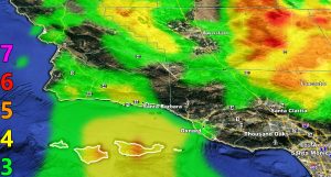
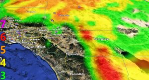
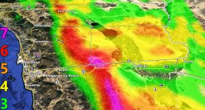
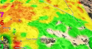
The SCWF Wind Intensity Model below is for this event so find your area there
7. Trees are broken or uprooted, building damage is considerable. – High Profile Vehicle Roll-Over CERTAIN.
6. SOME Trees are broken or uprooted, building damage is possible. – High Profile Vehicle Roll-Over Likely, Do NOT recommend Traveling in this zone
5. Slight damage occurs to buildings, shingles are blown off of roofs. HIGH WIND WARNING CRITERIA – High Profile Vehicle Roll-Over Possible if weight is not corrected.
4. Twigs and small branches are broken from trees, walking is difficult. Anything 4 and above will have blowing dust if conditions are dry, which does reduce visibility and make driving difficult …
3. Large trees sway, becoming difficult to walk. POWER SHUTDOWN THRESHOLD during any high fire risk. WIND ADVISORY CRITERIA
A fog advisory is in effect for the Cajon Pass later Friday into the night and into Saturday morning. Click here for that alert.
As for the rest of the area. The image in this article shows what will happen on Friday. The upper level low will be in the bight region, in what is the ‘Martin Storm Diamond’, however it lacks deep-layer moisture over the metros of LA/OC/SD/IE and the High/Low Desert so these areas will not see the thunderstorm explosion I expect within the moisture fields from Vandenberg AFB to the Cuddy Valley in the Southwest Kern County Mountains surrounding Pine Mountain Club where I have a Severe Weather Statement (click here for that) issued pending the Severe Thunderstorm Watch on your Friday for hail/damaging wind concerns in that small area, which is shaded red in the article image.
The rest of the shaded zones is the green zone for the metros simply showing an onshore flow effect with clouds, drizzle, and fog through Friday and Saturday. This will bring a cool-down for a bit, but don’t get use to it, the warming will return and as stated in the June 2020 forecast, the month will serve above average in temperatures so after the middle part of the month we will see this happen a lot more with numerous heatwave level events. Who knows, monsoon season starts June 15th in the Southwestern United States so we could get some moisture into the area to work with the heat and get some summer storms.
As always, stay tuned to Southern California Weather Force for official forecasts and updates in weather across Southern California
Join Southern California Weather Force main Facebook Page for future updates!
MICRO-CLIMATE ALERT FACEBOOK GROUPS: Find yours today!
Click here to join
Reading for another state? Join my national page – https://www.facebook.com/nwfweather/
All articles and micro-climate alerts can be delivered to you via the email alert service subscription and we are on a FREE TRIAL ALL SUMMER so CLICK HERE to join
MICRO-CLIMATE ALERT FACEBOOK GROUPS: Find yours today!
Click here to join
As always, stay tuned to official forecasts from Southern California Weather Force for updates …
For The Main Weather Facebook Page Click Here and Join.
End Article
FACEBOOK PAGES TO JOIN!
SOUTHERN CALIFORNIA WEATHER FORCE MAIN: Southern California Weather Force Office Main Page
BEHIND THE SCENES FORECASTS/UPDATE PAGE: Southern California Weather Force Meteorologist Page
FOR THE CALIFORNIA FAULT STRESS MODEL PAGE: For SCWF official updates to the California Fault Stress Model and more!
“PONDER THIS” SCIENCE ADVENTURE SHOW: A science adventure show developed here at Southern California Weather Force that is a fun ride!
INSTAGRAM AND TWITTER ACCOUNTS TO JOIN!
Instagram – https://www.instagram.com/socalweatherforce/
Twitter – https://twitter.com/SCweatherforce


