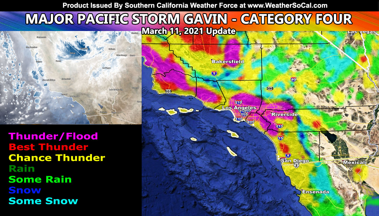
Major Pacific Storm GAVIN remains a category four over Southern California. Continuous intermittent showers and thunderstorms will continue through Friday. The Gorman Pass however today is under the gun for heavy snowfall and thunderstorms this afternoon, which likely cause a closure so be advised if traveling there that my forecast calls for such. The rest of you read on for details, including the main reason Southern California Weather Force is more accurate than NOAA in set areas.
Join Southern California Weather Force main Facebook Page by clicking here for future updates if you like what you are reading or seeing below!
GAVIN is terrorizing California with low snow levels, pass-affecting events, thunderstorms, heavy rain at times, and gusty winds. The gusty wind aspect will calm down today and Friday due to the center of the upper level low being nearly overhead. For today’s game-plan, the upper divergence (lift) in Gavin’s left quadrant will bring an explosive thunderstorm event over the Gorman Pass and Ventura/Santa Barbara County Mountains this afternoon. Clear skies today will make instability build for this to happen. These storms will slide southward after being stationary, causing a closure on the Gorman Pass so get through before they form. Southward they go, developing even into the SCV.
Thunderstorm dynamics today will be reserved for mainly inland metro areas, excluding San Diego proper. San Diego will have an upswing in activity tonight through Friday night, not so much today. You’re considered in a dry slot for most of today.
On Friday, the flow is north to south. Storms building over the Los Angeles and San Bernardino Mountains will slide southward into the LA Valley/Basin and Inland Empire zones. This looks similar to Major Pacific Storm Daimyo where on January 25th of this year we had a line of storms in the same areas, with heavy hail and even some snow in the higher valley locations. Click here to read what happened with that one on the SCWF FB Page
Southern California Weather Force will be closed from March 12th to March 15th. As stated before, we do have another system between that time so I’ll try to get something out by Friday morning before the office closes for the weekend. You also can take that time to appreciate the service when you need it and see what it is like without it for a system.
Southern California Weather Force is more accurate than NOAA. When I started as a teen we had veteran forecasters at NOAA who were born here. The forecasts were not too bad but needed work. Over the years these forecasters grew older and now they are mostly retired. When a kid comes out of college and applies for a job with NWS, that kid is assigned the first open spot they have. If the kid is from New York, they can be assigned an office in Southern California… or anywhere. The interns that were not born in Southern California are not above a forecaster that is almost 40 and was born here, that of who knows all the micro-climates and patterns that follow. That such person is me. Over 20+ years experience in forecasting here + born here equals the seniority level I have against ANY intern or new forecaster with NOAA.
This is why Southern California Weather Force is the most accurate weather source the region has and it should always be trusted and listen to when an alert goes out. So now you know why the forecasts are more accurate from one private weather office and one private citizen in this area … No intern or beginner forecaster shoved into a SoCal office for NOAA will ever be above me … and I take pride in saying that due to my many years of service here. So I don’t want to see comments or a peep on the validity of what I do against the interns.
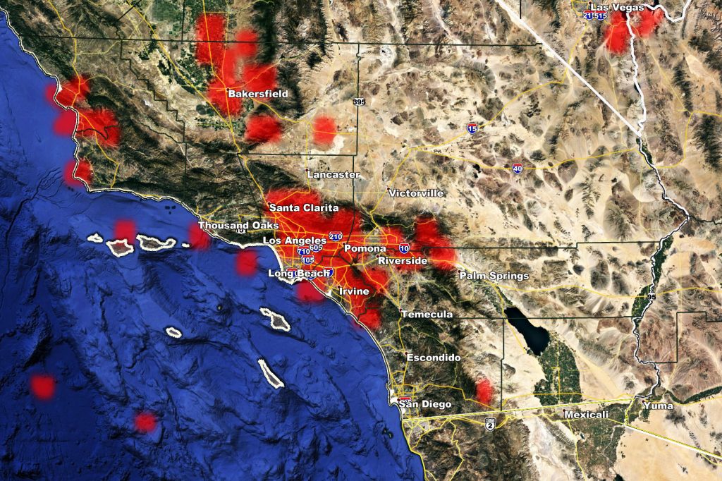
Lightning Strike Map as of 9am March 11, 2021 – You can compare it to the map above and notice that it is lining up, especially in the LA Metro areas to Bakersfield.
SCWF is on MeWe – https://mewe.com/p/southerncaliforniaweatherforce
MICRO-CLIMATE ALERTS DELIVERED BY EMAIL, FULL MEMBER SECTION WITH INTERACTION DURING EVENTS, ZOOM IN MODELS TO YOUR HOUSE/BUSINESS YOU CONTROL, AND MORE …
CLICK TO JOIN THIS WEBSITE AS A PREMIUM MEMBER
FACEBOOK PAGES TO JOIN!
SOUTHERN CALIFORNIA WEATHER FORCE MAIN: Southern California Weather Force Office Main Page
SOUTHERN CALIFORNIA WEATHER FORCE METEOROLOGIST: – Just my public figure page that isn’t as large so maybe you can reach me better at times.
INSTAGRAM, TWITTER, and NOW MEWE ACCOUNTS TO JOIN!
Instagram – https://www.instagram.com/socalweatherforce/
Twitter – https://twitter.com/SCweatherforce


