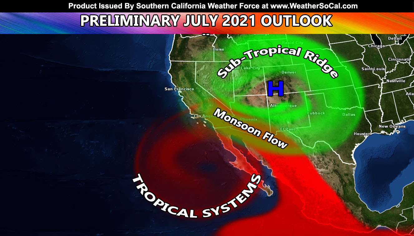
It is only Mid-June and we have used up three tropical storm names down in the Eastern Pacific Hurricane Basin, which is quite rare. This is telling of the active basin in my Summer 2021 forecast. So what does that mean for the monsoon and overall outlook of the atmosphere from here on out? … and don’t forget, the Summer 2021 discount to the member section and micro-climate email alerts you may not find elsewhere for floods, thunderstorms, etc ends TODAY, the 15th so grab it while it lasts… Read on for details below …
SCWF MEMBER SECTION – CLICK HERE TO VIEW THE CONTROLLABLE ZOOM IN HEAT MODEL FOR THIS EVENT –
In my official 2021 Summer Forecast, I predicted that we would see a hint of monsoonal flow by mid-June (CLICK HERE FOR THAT). What we will see will be a slight upswing in monsoon moisture Wednesday through Friday of this week across the local area in spots, maybe to the valley/coast but mainly The San Bernardino (Big Bear), Riverside, and San Diego County Mountains. It also may promote a fire weather hazard so that wording is officially in my forecast. We should have lightning in those areas between Wednesday and Friday, more likely Thursday and Friday as the peak. We have the four corners high starting to establish, however will be knocked back down in the next week. This is quite common as the upper jet stream is continuing to retreat north into Canada. Once it does so, I’d say the end month and into the month of July looks active, with numerous shots of monsoonal moisture moving in. What we are seeing now is a four corners ridge that is needed yes, but it is lacking the close Pacific Hurricanes south of here to draw the moisture into Mexico and shove it into the Southwestern United States. This will further establish over the next month.
Many forecasters want to keep the ridge south into Northwest Mexico this Summer. I simply do not see that given my forecast stated I am going for an above-average Pacific Hurricane Season. This would actually shove the ridge of high pressure north into Utah and Colorado. This is where you want it to be, not over the four corners. Every forecaster states a four-corners ridge and while that may be helpful, the stronger intrusions into the Southwest, including CA/NV is when the ridge is over Utah and Colorado. This is the scenario that will play out a number of times in July and the month will become an active monsoon month for much of the region.
Temperature profiles will be average to even cooler than average in the region. This is because once the monsoon flow establishes, we enter in humidity (yuck) and knock down the high temperatures. We won’t see those 115+ degree dry heat temperatures once the flow establishes, but we will contend with the humidity factor, which can be even worse for some. Many will ask themselves this Summer, did the Southwest turn into Florida?! Our ‘dry heat’ factor will be going away as we dive deeper into the Summer months.
This could be setting up for an active Fall as well as leftover moisture from the stronger hurricane season is lifted northward with approaching storm systems… but that is a bit far away. I’ll concentrate from now on month-by-month forecasts, and seasonal (three-month) forecasts, that you just read.
GET EMAIL ALERTS AND ENTER THE MEMBER SECTION ON THE SITE: THE OFFER IS ONLY TILL JUNE 15TH! Both Southern California Weather Force and Arizona Weather Force have a cheap Summer 2021 discount to supercharge this service you already get on social media for free. If you do not want to miss any articles this season because social media does not show you for hours or even days (common) and want to get custom email alerts such as thunderstorm, severe thunderstorm, flood, heat, or tornado alerts along with a controllable member section model for each during the events in YOUR area, sign-up for the premium member package, which is only $10 for the Summer. Read below for details on how to join this offer.
REMEMBER… your continued want for this service is what keeps the server running and paid for. A big bill is coming in the Fall and if I can get enough signed up this Summer, I can extend everyone’s Summer 2021 package through September. Thanks for your help!
SOUTHERN CALIFORNIA WEATHER FORCE – Click here to Join Southern California Weather Force‘s package
Southern California Weather Force Facebook Page is here
SCWF is on MeWe – https://mewe.com/p/southerncaliforniaweatherforce
FACEBOOK PAGES TO JOIN!
SOUTHERN CALIFORNIA WEATHER FORCE MAIN: Southern California Weather Force Office Main Page
SOUTHERN CALIFORNIA WEATHER FORCE METEOROLOGIST: – Just my public figure page that isn’t as large so maybe you can reach me better at times.
NATIONAL WEATHER FORCE – Join my NATIONAL page for higher-end events like flood, tornado, hurricanes, and more –
INSTAGRAM, TWITTER, and NOW MEWE ACCOUNTS TO JOIN!
Instagram – https://www.instagram.com/socalweatherforce/
Twitter – https://twitter.com/SCweatherforce

