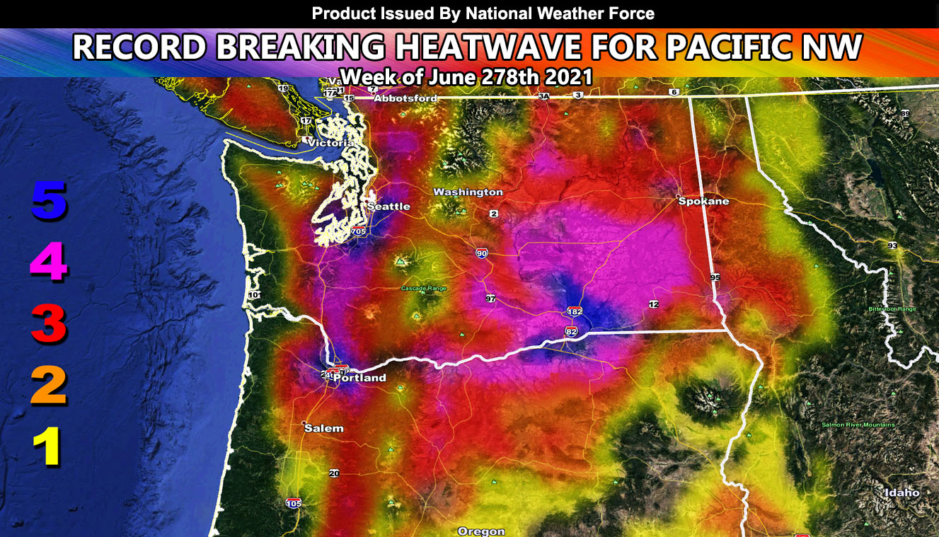
National Weather Force has issued a High Heat Warning. Back on June 21st I warned of the coming heatwave that you had plenty of time to prepare for so here is your final warning … now an abnormally strong ridge of high pressure will form over the Pacific Northwest starting Sunday and maximizing through Monday and Tuesday. This ridge has brought a LEVEL FIVE reading on the National Weather Force scale, something not seen anywhere but the Desert Southwest and the most dangerous value on the model for Seattle and Portland. You are not used to this, take precautions as I challenge NOAA in saying their forecast temp is still too low so read on for details …
IF READING THIS FROM AZWF or SCWF and in the PAC NW REGION – Click here to join the National Weather Force FB Page
Back on June 21st, I released an article for viewers of the Pacific Northwest. As National Weather Force grows with your help in sharing the information across social media then more people would see it. You can click here to see that article forecast. At the time of my forecast release, NOAA had a high-temperature forecast for Portland and Seattle in the upper 90s touching 100. A few days after they upped it to 103. Now they are at 109. I have stated that 115F is possible with this ridge of high pressure since the 21st and I have no doubt in my mind they will eventually last-minute upgrade to my forecast. But if they do not, you had your warning.
In the Desert Southwest, I have developed a heat model, scaling 1-5 and I’ll be adding a 6 soon for cooked medium-rare. This scale is not a temperature scale, but more of a scale to tell you what it would be like out there. Not many of you are used to the heat that will come so you need to prepare for a taste of what happens in Phoenix and Palms Springs each Summer for days on end.
This scale works for the image above in this article –
NEW FLAT RATE TIER PROGRAM – GET CUSTOM EMAIL WEATHER ALERTS IN YOUR AREA AND ENTER THE MEMBER SECTION ON THE SITE: Summer 2021 rates – If you get in after June 1st it is only $10, if after July 1st only $6. If after August 1st only $3 to finish off the Summer Quarterly Tier. Fall, Winter, and Spring will have their own tiers starting at $20. Tier start dates to renew at the base price will be September 1st, December 1st, March 1st, and June 1st and each month during the quarter shaves off $7 until the next tier reset.
Both Southern California Weather Force and Arizona Weather Force have a cheap seasonal quarterly discount to supercharge this service you already get on social media for free. If you do not want to miss any articles this season because social media does not show you for hours or even days (common) and want to get custom email alerts such as thunderstorm, severe thunderstorm, flood, heat, or tornado alerts along with a controllable member section model for each during the events in YOUR area, sign-up for the premium member package. Click here to read more
REMEMBER… your continued want for this service is what keeps the server running and paid for. Thanks for your help!
SOUTHERN CALIFORNIA WEATHER FORCE – Click here to Join Southern California Weather Force‘s package
Southern California Weather Force Facebook Page is here
SCWF is on MeWe – https://mewe.com/p/southerncaliforniaweatherforce
FACEBOOK PAGES TO JOIN!
SOUTHERN CALIFORNIA WEATHER FORCE MAIN: Southern California Weather Force Office Main Page
SOUTHERN CALIFORNIA WEATHER FORCE METEOROLOGIST: – Just my public figure page that isn’t as large so maybe you can reach me better at times.
NATIONAL WEATHER FORCE – Join my NATIONAL page for higher-end events like flood, tornado, hurricanes, and more –
INSTAGRAM, TWITTER, and NOW MEWE ACCOUNTS TO JOIN!
Instagram – https://www.instagram.com/socalweatherforce/
Twitter – https://twitter.com/SCweatherforce

