
Southern California Weather Force has issued a LONG RANGE WEATHER ADVISORY for multiple storm systems to impact the region starting after December 21st and going storm after storm through Christmas and through to New Years in what will push this month to way above average for rainfall so read on for details …
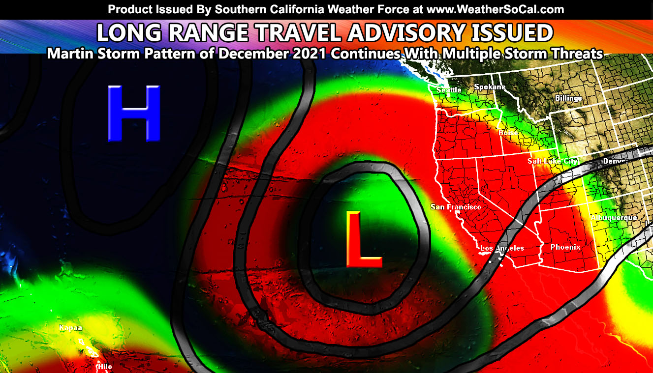
An omega-block has set up in the Pacific Ocean. An Omega-block means that an upper-level ridge north of Hawaii is creating two low pressure systems on each side of it. Our side, the eastern periphery, will affect the Southwestern United States after December 21st and go through the end of the month. Storms systems in this will be a mixed bag, some having wintry weather and others a full pineapple express.
Omega-blocks are our equivalent to major tornado outbreaks out east, a number of people die in them, whether by the flooding or the ice/snow storms that accompany it.
Means the ridge is stuck in place north of Hawaii and cancelling the low pressure centers on each side of it out, making them stuck as well.
if you have a ridge, which spins clockwise north of Hawaii.. like gears on a clock you’ll have opposite spins (low pressure) on the left and right of it.
They are spinning together and will not move, like gears on a clock. Nothing is moving them from the 21st through end month. A low will be stuck west of here pumping moisture in.
these systems also pose a very dangerous ice storm chance. When the ground freezes above 3k, overnight, a system with moisture to the SW coming in say overnight/morning will drop rainfall on the ground and the freezing surface will make the water freeze instantly and create an ice storm, ice on the roads, and ice on the powerlines/trees which also causes a lot of long term power outages.
Means the ridge is stuck in place north of Hawaii and cancelling the low pressure centers on each side of it out, making them stuck as well.
if you have a ridge, which spins clockwise north of Hawaii.. like gears on a block you’ll have opposite spins (low pressure) on the left and right of it.
They are spinning together and will not move, like gears on a clock. Nothing is moving them from the 21st through end month. A low will be stuck west of here pumping moisture in.
these systems also pose a very dangerous ice storm chance. When the ground freezes above 3k, overnight, a system with moisture to the SW coming in say overnight/morning will drop rainfall on the ground and the freezing surface will make the water freeze instantly and create an ice storm, ice on the roads, and ice on the powerlines/trees which also causes a lot of long term power outages.
This is precisely what I predicted in my November 5th article for the region. Did you miss it?? Click here to read it. In the article I talked about how this year’s La Nina would not act as such. The Pacific Ocean was knocking on the 2010-2011 La Nina season where we did end up with a ton of storms regardless of it being La Nina. This is very similar and I still expect to have a lot of rainfall. Every single other source is predicting drier than normal in this region. I mean, in Arizona they did the same thing for the last monsoon period when I went above average rainfall and it blew that out of the water.
Do me a favor, whatever NOAA predicts, go opposite and you’ll have a better forecast outlook.
Even though some of these systems will feature warmer storms this month, we will have colder ones as well. One thing I MUST STRESS is this type of pattern is what causes ICE STORMS for the mountain passes of both Southern California and Arizona. As freezing temperatures happen overnight, a system to the south bringing a warm front through in the morning would create an atmosphere where the rain would freeze on contact with the ground. Such scenarios have caused deaths and numerous pile-ups on all mountain passes, especially the Cajon Pass in Southern California, regarded and voted as California’s most dangerous stretch of highway where there is a death or injury every single day.
So there you have it, the Martin Storm Pattern of December 2021 will remain intact through the end of the month. One should say to prepare for storms in or around the area for Christmas Eve / Christmas’s time-frame.
A long range weather advisory is issued during times of heavy travel where dangerous weather conditions are to be expected in the medium to long range so you have time to prepare. You are urged to continue to follow the forecasts here at Southern California Weather Force for further information.
A Martin Storm Pattern means that the pattern was predicted before apps or government/private sources, and since my last name is Martin, like a person who discovered a comet, it is only fair this coming pattern is the Martin Storm Pattern of December 2021. There will be MANY Martin Storm Patterns due to my ability to go longer range in weather.
If you do have plans to travel during that time, I would suggest continuing to monitor the latest forecasts here at Southern California Weather Force, however you get them, either by the member email alert system, social media, or checking the main website daily for updates. The ABOUT section of this site will tell you all you need to know about it for navigation. Click here to read the about section.
WANT MORE? The MAIN PAGE of this website has every alert/article issued at current. CLICK HERE TO GO
The following articles were talked about in this write-up – You can read them and see how this forecast was done and evolved …
November 5, 2021
HOT TOPIC: 2021-2022 Seasonal Weather Forecast Released For Southwestern United States; Detailed Maps and Discussion Within
November 29, 2021
December 2021 Weather Pattern Forecast Outlook For Southern California; December Arctic Blasts and Storms
How to get these alerts with a premium subscription via e-mail by micro-climate zone AND/OR Get the GPS models for this event on your device enabled? (100 percent delivery time)
Click Here To Join The Season Tier
Join The Main Southern California Weather Force Facebook Group (50 percent delivery time) – You can join the main SCWF page as well through that group.
Click Here To Join The Page Today
FACEBOOK PAGES TO JOIN!
SOUTHERN CALIFORNIA WEATHER FORCE MAIN: Southern California Weather Force Office Main Page
SOUTHERN CALIFORNIA WEATHER FORCE METEOROLOGIST: – Just my public figure page that isn’t as large so maybe you can reach me better at times.
INSTAGRAM, TWITTER, TO JOIN!
Instagram – https://www.instagram.com/socalweatherforce/
Twitter – https://twitter.com/SCweatherforce
Southern California Weather Force is a custom weather alert service that began in September 1999 off and is regarded as the most accurate weather service in the region, offering custom alerts, maps, and models to help save life and property. The work done here is never 100% accurate, but it comes pretty close. Southern California Weather Force runs on zones, so if an event happens in a zone that is 10 miles from the border of your zone, the forecast is still valid to activate your zone’s alert system. A company quote to the public is that of “The Joker” and tells other agencies in weather this all the time… “This world deserves a better class of meteorologist… and I’m gonna give it to them”… out-forecasting even the National Weather Service with lead-time and precision, which makes this service a focus of ridicule and envy in the weather community due to having such accuracy. Alerts issued here are issued custom from this office and this office alone. You may not even hear it elsewhere, but if one is issued near or in your area, listen up because “if you do not wish to die in weather, follow, it’ll save your life one day.”