Welcome back to the site after the holiday week. I hope you had a great Christmas and a Happy New Year so far. We start off the new year here with the January 2022 forecast. And I will say, it looks opposite of December 2021’s with a different atmosphere and this is for both Southern California and Arizona Weather Force so read on for details after the first paragraph …
NOTE: The Winter 2022 Tier for MEMBERS and ANYONE INTERESTED is OPEN FOR JANUARY THROUGH END FEBRUARY WITH REDUCED SEASONAL TIER RATES. This is when you get these delivered to your e-mail of choosing AND get your own micro-climate alert system based on your zone for my winter and storm alert products that are not posted on social media when issued. You also get the member section, which has controllable models like rain, wind, snow, in high resolution along with a GPS feature which is updated when an event is in the area –
CLICK HERE TO LEARN MORE AND SIGN-UP –
If you are a current member and NOT on a monthly plan, your Winter 2022 tier expires March 1st, but do not renew until the Spring 2022 tier is opened, which you’ll receive an email then.
ARTICLE START
The December 2021 forecast went exactly as thought, word for word in both regions. Los Angeles had near 9.50″ of rainfall during the month alone with a normal amount of 2.48″, which is unprecedented and will be the third highest amount during the month of December since records began, only behind 1989 and 2010. If you click here, this is exactly what my model showed, which is telling me further that we remain on track to keep getting the long range right. So, what about this month?
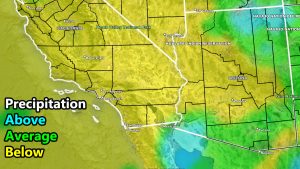
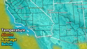
This month a raging jet into the Pacific Northwest, which has no blocking. No blocking means that we will continue to get the colder air out of the west in both regions of Southern California and Arizona, but it also means much drier conditions. My model is showing drier than normal conditions for most of California, majorly drier than normal for Southern California than Northern. There are indications that weak cutoff systems under the raging jet could bring more precipitation to Tucson than say even Phoenix, but the amount just doesn’t look so high, but bears watching for that area sometime mid-month.
With that being said, the colder than normal temperatures are already being felt in both regions. In long range forecast, Los Angeles is used as a base. In my long range forecast for the season, I predicted 7-14″ of rainfall with a likelihood of 10-14″. We are already at 10″ for Los Angeles, which shows we are on track here in the Desert Southwest – with that number not even close to being a traditional La Nina. That means that La Nina is NOT controlling the current weather pattern for the season thus far. It will definitely seem like it in January though, but we still have February, March, and April left, that of which can easily add more storms into the forecast.
So here is the breakdown – If you want to fix your roof, this is the best month to do so just in-case feb/mar/apr become active again
Southern California
Precipitation: Below Average
Temperatures: Below Average
Arizona
Precipitation: Equal chances use the map provided below.
Temperature: Below Average
WANT MORE? The MAIN PAGE of this website has every alert/article issued at current. CLICK HERE TO GO
The following articles were talked about in this write-up
November 5, 2021
HOT TOPIC: 2021-2022 Seasonal Weather Forecast Released For Southwestern United States; Detailed Maps and Discussion Within
November 29, 2021
December 2021 Weather Pattern Forecast Outlook For Southern California; December Arctic Blasts and Storms
How to get these alerts with a premium subscription via e-mail by micro-climate zone AND/OR Get the GPS models for all events on your device enabled? (100 percent delivery time)
Click Here To Join The Season Tier
Join The Main Southern California Weather Force Facebook Group (50 percent delivery time) – You can join the main SCWF page as well through that group.
Click Here To Join The Page Today
FACEBOOK PAGES TO JOIN!
SOUTHERN CALIFORNIA WEATHER FORCE MAIN: Southern California Weather Force Office Main Page
SOUTHERN CALIFORNIA WEATHER FORCE METEOROLOGIST: – Just my public figure page that isn’t as large so maybe you can reach me better at times.
INSTAGRAM, TWITTER, TO JOIN!
Instagram – https://www.instagram.com/socalweatherforce/
Twitter – https://twitter.com/SCweatherforce
Southern California Weather Force is a custom weather alert service that began in September 1999 off and is regarded as the most accurate weather service in the region, offering custom alerts, maps, and models to help save life and property. The work done here is never 100% accurate, but it comes pretty close. Southern California Weather Force runs on zones, so if an event happens in a zone that is 10 miles from the border of your zone, the forecast is still valid to activate your zone’s alert system. A company quote to the public is that of “The Joker” and tells other agencies in weather this all the time… “This world deserves a better class of meteorologist… and I’m gonna give it to them”… out-forecasting even the National Weather Service with lead-time and precision, which makes this service a focus of ridicule and envy in the weather community due to having such accuracy. Alerts issued here are issued custom from this office and this office alone. You may not even hear it elsewhere, but if one is issued near or in your area, listen up because “if you do not wish to die in weather, follow, it’ll save your life one day.”


