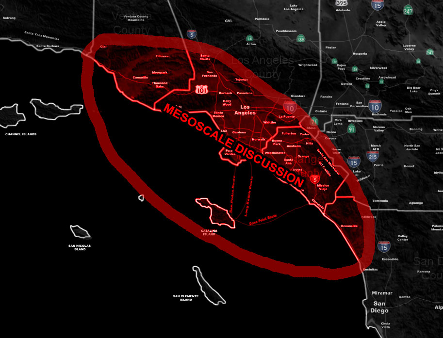
Issued Zones: Ventura, Los Angeles, Orange County Coast and Basin … San Diego Coast Oceanside and possibly Encinitas …
Site: Southern California Weather Force has issued a Mesoscale Discussion concerning the upgrade from Severe Thunderstorm Watch to Tornado Watch within the next several hours for this afternoon through later evening …
Date Issued: 3/28/22 at 4:40am local
Forecast: A powerful storm system is moving in as we speak and as of the release of this discussion, the first front is now nearing Santa Barbara, on time to the forecast. This front still has the chance of thunderstorms as it moves east through VT/LA throughout the day today.
However the focus is the second front, which is already sparking thunderstorms well offshore. This is signaling that it will have thunderstorms when it reaches us, a lot of them. As it reaches the mesoscale discussion area later this evening, I expect it to be very close to the surface low, in fact so close that one of the tornadoes will be a part of the surface low itself.
Southeasterly flow present as stated in previous updates will bring the risk of large waterspouts landfalling into tornadoes. With the instability over the land present, these could also form over the Basins as well.
THIS WOULD UPGRADE THE SYSTEM TO CATEGORY SIX IF ISSUED … This would be the first time I’ve used a Category Six out of the SCWF 1-6 storm intensity/rarity scale…
This decision will be made over the day …
A Mesoscale Discussion means that conditions are being monitored on the meso (small) scale atmosphere to upgrade the outlined area in a higher class convective (thunderstorm) type watch …
How to get these alerts with a premium subscription via e-mail by micro-climate zone AND/OR Get the GPS models for this event on your device enabled? If you read this from the website or social media links, this option is the best to go so you get them delivered every single time without having to look for them (100 percent delivery time)
Click Here To Join The Season Tier
Join The Main Southern California Weather Force Facebook Group (50 percent delivery time) – You can join the main SCWF page as well through that group.
Click Here To Join The Page Today
10 mile rule: These alerts issued on this site means that within your zone and 10 miles from you will see the event forecast for. You may or may not see the event but it means you are in the zone or 10 miles from where someone will.
Southern California Weather Force is a custom weather alert service that began in September 1999 off and is regarded as the most accurate weather service in the region, offering custom alerts, maps, and models to help save life and property. The work done here is never 100% accurate, but it comes pretty close. Southern California Weather Force runs on zones, so if an event happens in a zone that is 10 miles from the border of your zone, the forecast is still valid to activate your zone’s alert system. A company quote to the public is that of “The Joker” and tells other agencies in weather this all the time… “This world deserves a better class of meteorologist… and I’m gonna give it to them”… out-forecasting even the National Weather Service with lead-time and precision, which makes this service a focus of ridicule and envy in the weather community due to having such accuracy. Alerts issued here are issued custom from this office and this office alone. You may not even hear it elsewhere, but if one is issued near or in your area, listen up because “if you do not wish to die in weather, follow, it’ll save your life one day.”
