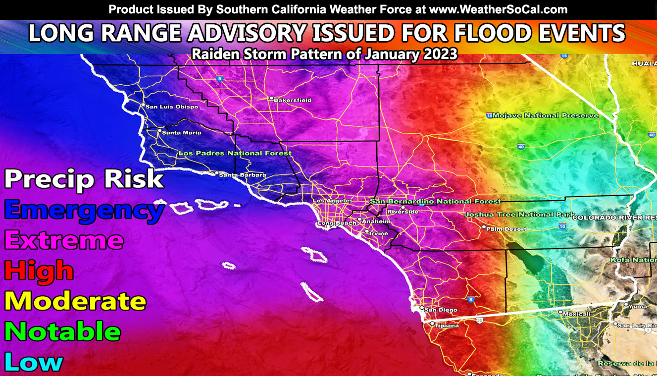
Southern California Weather Force has issued another Long-Range Weather Advisory for Southern California with another Atmospheric River that will last from the end of this next weekend (January 7-8) and through the middle part of the month, with multiple storm systems in a line, including the entire major metropolitan areas under either an extreme or emergency risk for flooding. This is another Raiden Storm Pattern, but since it will envelope a lot of the month, it will be the Raiden Storm Pattern of January 2023 so read on for details …
WANT THESE DELIVERED WITH ALL THOSE PERKS INCLUDING BEING ON THE MICRO-CLIMATE ALERT SYSTEM AND MODELS DURING EVENTS BECAUSE NOT EVERY ALERT IS POSTED ON SOCIAL MEDIA FROM THIS WEATHER OFFICE – JOIN TODAY BY CLICKING HERE – Southern California Weather Force Subscriber System – Southern California Weather Force
Join the Facebook Page for Further Updates If You Have Not Yet!
SOUTHERN CALIFORNIA WEATHER FORCE MAIN:
The upper-level jet stream that now extends from the United States Mainland westward to Asia is remaining in place. A ridge of high pressure south of Hawaii is continuing to block any type of amplitude process within this system. This is something that has not been seen for a very long time, probably a once in 20-year event. This is continuing to eject tropical moisture into California.
This next Atmospheric River will be the second one this season that will bring high levels of flooding risk to Southern California. This might very well exceed the current pattern we are in. Southern California Weather Force Long Range Models are indicating emergency conditions in San Luis Obispo, Santa Barbara, and Ventura County, with extreme conditions covering the metros of Los Angeles, Orange, San Diego, and the Inland Empire areas. Extreme risk conditions also extend in the Metro High Desert locations as we. The model indication through mid-month that shows a high risk in Palm Springs is indicating that a lot of these storms will make it over the mountains into the Coachella Valley as well.
As such, January 2023 will be above average in rainfall as the official Southern California Weather Force projection.
This comes months after the forecast here at Southern California Weather Force stated that the 2022-2023 season would not be a normal La Nina (Click Here To Read That), and the margin of forecast precipitation in Los Angeles would be 14-18″ of rain, middle part being 16″. Can we exceed it? It all depends on the rest of the season after this month, but trends are looking that the margin will be met, where NOAA went warm and dry due to a La Nina and here at Southern California Weather Force I went opposite. La Nina and El Nino do not dictate what happens here. There are more factors in place many in the field do not understand yet, which is where I come in.
A Raiden Storm Pattern is a pattern in the long range that was predicted before any other source or app available today, named after the discoverer as a comet is named after their discover. Weather forecasting is a gray area, and no prediction is ever respected or covered by others in the field, therefore it had to be done to create the Raiden Storm Pattern term.
For the next pattern, Southern California Weather Force will be in charge of all the alerts from flood, winter, wind, marine, and whatever is needed to make sure those who follow and/or are reading this now take the proper precautions.
WANT THESE DELIVERED WITH ALL THOSE PERKS INCLUDING BEING ON THE MICRO-CLIMATE ALERT SYSTEM AND MODELS DURING EVENTS BECAUSE NOT EVERY ALERT IS POSTED ON SOCIAL MEDIA FROM THIS WEATHER OFFICE – JOIN TODAY BY CLICKING HERE – Southern California Weather Force Subscriber System – Southern California Weather Force
Join The Main Southern California Weather Force Facebook Group (50 percent delivery time) – You can join the main SCWF page as well through that group.
Click Here To Join The Page Today

