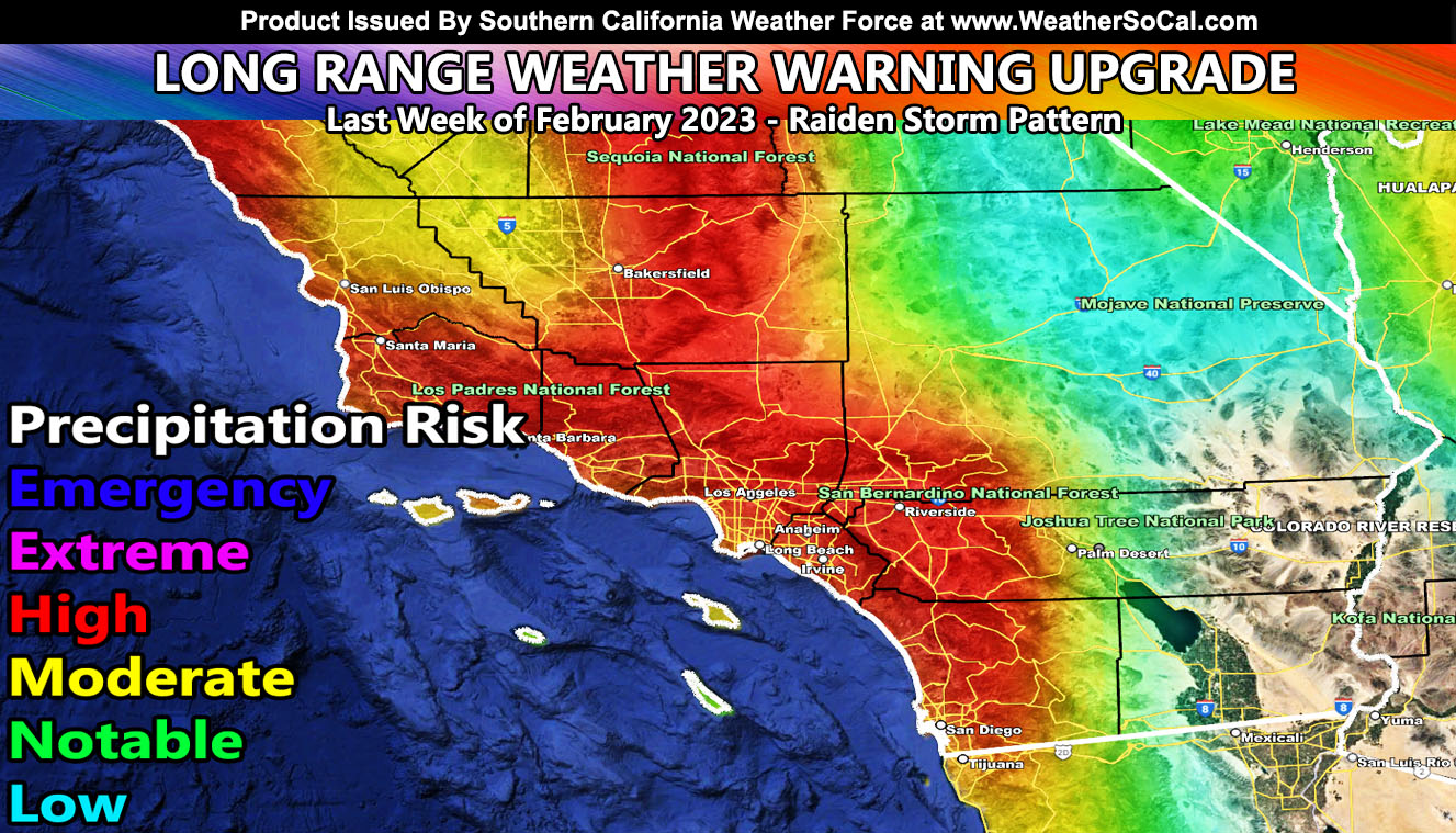
Southern California Weather Force has issued upgraded the Long-Range Weather Advisory from back on February 8th to now a Long-Range Weather Warning as the next Raiden Storm Pattern develops so read on for details and important notes, including NASCAR weekend …
Join the Facebook Page for Further Updates If You Have Not Yet!
SOUTHERN CALIFORNIA WEATHER FORCE MAIN:
The week will be off and on with the onshore flow, but I do think that NASCAR weekend as going to be stormy here in the southland. The SCWF Model clearly shows we went from notable back on February 8th for this period to high risk now. I do think we will see a higher risk than that, especially in the Santa Barbara / Ventura / Los Angeles areas as these storms will have a strong southerly flow in the low levels. In addition to that, these storms are on the colder side with some of the impulses, which means we can get snow-levels below that 4,000 FT mark to affect travel in the passes, thus I will be closely monitoring near or on the weekend of February 25th.
Back on February 8th I issued a Long-Range Weather Advisory for a pattern developing after February 19th, or the week thereof. Click here to read that credit. This looks to be shaping up nicely. As the advisory stated, there was room for upgrade and that has officially now happened with this warning.
But don’t stop reading there, this also was predicted on January 31st with the February 2023 forecast. It stated that the middle/last part of this month will be active while the beginning would not be. This is exactly what is happening. Click here to read that credit. That would make this another long range forecast that is credited for 25 days beforehand from even happening and many days before any source saw it.
This pattern will push us above average in rainfall for the season, thus verifying the Fall 2022 forecast that I released stating it would be colder and wetter this season while every other source said warm and dry. This is why La Nina or El Nino does NOT matter. Click here for that credit archive.
Once again, because the credit was called here at Southern California Weather Force before absolutely any other source, including incompetency of NOAA and apps, this is called a Raiden Storm Pattern. A Raiden Storm Pattern is when a long-range pattern is predicted first, similar to someone writing a book and/or discovering a comet and therefore will bear the name of the discoverer as having full seniority.
ONE THING I will keep saying is do not comment or message me saying “my app says rain coming is it true” or anything like that. I’ve given long range updates already and those other sources have no business being in the same league as what I have already given you. Always check the main website and/or social media accounts because nothing passes by me, it is the reader who does not look for my past forecast updates. No other source matters as long as I am alive so let’s remember this. Until any source living or operating today gets ahead of me, there is no need to upset me by mentioning them on a forecast I already put out long beforehand.
Now I know some of this sounds like I am a mean person, but I protect my hard work and expect others in the field to respect that fact as well as others who do not yet know SCWF exists.
So Southern California Weather Force will be the official source once again for weather alerts/forecasts as we near the pattern start and peak so stay tuned for further updates however you receive them.
Join the Facebook Page for Further Updates If You Have Not Yet!
SOUTHERN CALIFORNIA WEATHER FORCE MAIN:
Southern California Weather Force Twitter – CLICK HERE
WANT THESE DELIVERED WITH ALL THOSE PERKS INCLUDING BEING ON THE MICRO-CLIMATE ALERT SYSTEM AND MODELS DURING EVENTS BECAUSE NOT EVERY ALERT IS POSTED ON SOCIAL MEDIA FROM THIS WEATHER OFFICE – JOIN TODAY BY CLICKING HERE – Southern California Weather Force Subscriber System – Southern California Weather Force

