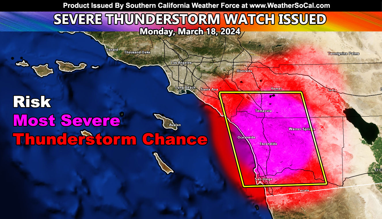
Southern California Weather Force has upgraded yesterday’s Special Weather Statement to a full Severe Thunderstorm Watch, officially now issued for today.
Latest in the upper levels shows the cutoff low that has brought all this ‘odd weather’ to the region with a north to south flow around the western periphery of it will move directly near the watch zone. Storms are expected to utilize the available instability and lift. This is what should have been issued on Saturday, but the timing was wrong. So again, like said in the Special Weather Statement, it was a timing mistake for the magnitude of such an event.
Storms today will be strongest where the onshore flow hits the southwest slope of any mountain area within the watch area. That means the strongest will no doubt be southwest of the Riverside and San Diego County Mountains, with some storm activity along and southwest of the Santa Ana Mountains of Orange County. Activity will move off there and into the populated areas.
Severe Wind and hail will be possible along with the chance of tornado activity, especially at the center of the dynamics.
As stated yesterday, the chance of Los Angeles seeing widespread activity is low, but there will be a chance of some activity for the populated zone of Ventura County. Both counties will not get a notification due to the isolated nature of this event. The boxed area within this article clearly shows Southern Inland Empire through some of Orange County, and the center if San Diego County.
If I had to pick an area today, I would be ‘storm chasing’ in, I would go to around the Fallbrook area of San Diego County.
That is it, refer to reference A for the Special Weather Statement issued yesterday for today’s event –
Reference A (Initial Call) – https://www.southerncaliforniaweatherforce.com/2024/03/17/special-weather-statement-cutoff-low-retrogrades-west-to-effect-southern-california-for-monday-march-18th-2024-details/
Stay tuned to Southern California Weather Force for updates to this, or any other future forecasts …
– Raiden Storm –
https://www.southerncaliforniaweatherforce.com
Master General Meteorologist – is a consulting meteorologist for over 50 companies, including energy, agriculture, aviation, marine, leisure, and many more areas. He has certs from Mississippi State for broadcast met and Penn State forecasting certs MET 101, 241, 341 and 361 as a meteorologist, but before then was completely self-taught, barely learning a thing from the schools that he did not already know.
Both short and long-range is very important to know in those jobs so you can bet on accuracy here. He is versed in fields like Western USA, Tornadoes, Floods, Hurricanes, High Winds, Fire Behavior, Snow and Blizzards, Short Range, Long Range, Seasonal, and Life-Threatening decisions with over 25 years’ experience, out forecasting all weather services available today with lead-time and precision, which makes him a focus of ridicule and envy.
NOTE: Alerts are posted on here, be it a tornado watch, etc, and these alerts are issued from this office and nowhere else. At times, which is often, you will see an alert forecast posted on here that you do not see elsewhere.

